Bahia Bustamante
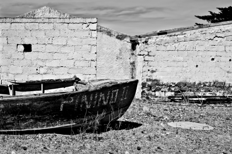
Bahia Bustamante, Days Past, Nikon D700 50mm f/1.8
Hidden on the Argentine coast is a small seaweed and sheep farm that calls themselves the Galapagos of Argentina. While that is a huge claim, it is not far from the truth, when you compare the arid land to the rich life along this portion of the cold Atlantic Coast. Bahia Bustamante is located 3 hours outside of Trelew in the state of Chubut. It offers 6 Sea Houses that are all-inclusive and a dozen Step House that are a la carte. We decided to visit this unique and remote reserve after Amanda read a NY Times article back in 2010. I planned our vacation around spending New Years Eve at BB. For those who select the all-inclusive Sea Houses you are able to experience daily adventures that include hikes along remote beaches, boat adventure to view penguins and sea lions, visit penguin island, walk the purified forest, and horse back riding. The eating experience is excellent as well. Matias, the proprietor and grandson of the founder hired two excellent chefs that provide three gourmet meals a days. Add a Patagonia Amber ale and you will be in heaven. Below are some the images from our trip. Enjoy and more to come.
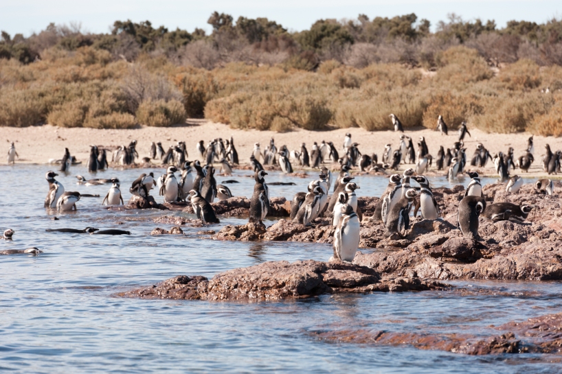
Bahia Bustamante, Penguin Island, Nikon D700 70-200mm
Bahia Bustamante, Mess Hall with Activity Board
Bahia Bustamante, Front Porch with a Patagonia Cerveza
The daily expeditions for the most part begin with a fun and nostalgic Land Rover Defender 4×4 ride. The images below are from our walks along the beach, boat excursions, and visits to Penguin Island and the petrified forest.
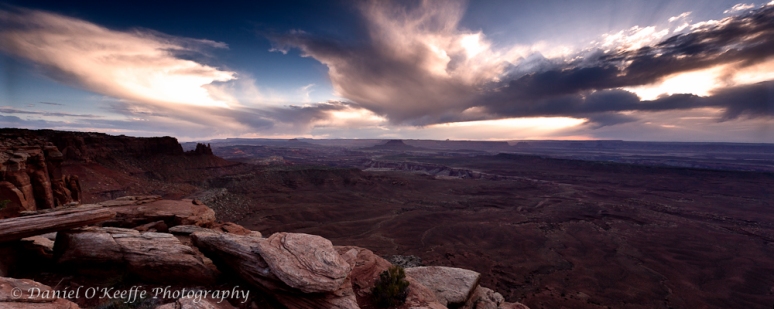
Bahia Bustamante Coast, Nikon D700 14-24mm f/8
Bahia Bustamante, Nikon D700 70-200mm
Bahia Bustamante, Sun Bathing Sea Lion, Nikon D700 70-200mm
Bahia Bustamante Tide Pools, Nikon D700 70-200mm
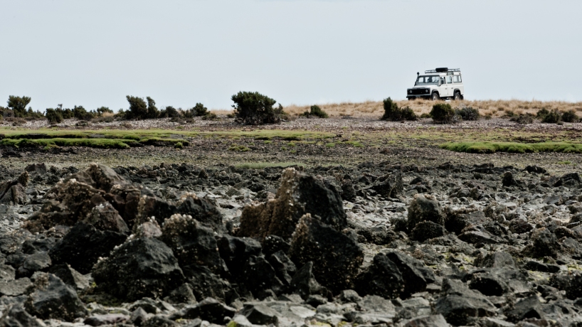
Bahia Bustamante, Land Rover Defender at Penguin Island, Nikon D700, 70-200mm
Bahia Bustamante, Penguin Island Nikon D700 70-200mm
Bahia Bustamante, Penguin Island
Bahia Bustamante, Boat Excursion, D700 70-200mm
Bahia Bustamante Boat Excursion, D700 70-200mm
Bahia Bustamante Boat Excursion, Bull Seal Lion, D700 70-200mm
Bahia Bustamante, Sea Lion Orgy D700 70-200mm
Bahia Bustamante Boat Excursion, Perfect Water D700 70-200mm

Bahia Bustamante, Sea House New Years Eve, D700 70-200mm
Easter Day with Hudson at Ocean Beach
Hudson, Amanda, and I visited Ocean Beach for a quick walk on this fine Easter Day. The tide was particularly high, so I made good use of my 9-stop ND filter on my 70-200mm VR II. It is such a fun combo. Enjoy!
Kudos to Amanda for keeping him in one place.
Down Hudson…Stay
I used my 9 stop nd filter to slow the exposure to 8 seconds.
The Ice Plant flowers look like Easter Eggs.
Death Valley and Thanksgiving Left Overs
Death Valley Bad Water Salt Flats at Sunrise, Nikon D700 24-70mm f/18 ISO 200
Death Valley is a place that everyone hears about, but few go to visit the lowest and driest place in North America. Strangely or not strange at all, Death Valley lies just 86 miles from the highest peak in the contiguous United States. Ever since I became a phototag in 2006, I have wanted to photograph the texure and scenery of Death Valley. Finally, it happened the weekend after Thanksgiving 2011. Fueled with Colleen’s excellent Thanksgiving leftovers, Pete and myself made the endless drive from SF to Death Valley. Our plan was to camp at Furnace Creek for three night to explore Badwater (Sunrise pic above and below), Mesquite Dunes, and Dante’s View. However, the Sunset campground is not suited for campers due to the many RVs, so we quickly decided to visit two remote locations, “The Raceway” and Eureka Sand Dunes.
Badwater is an excellent photographic subject at sunrise and at sunset. The salt beds form hexagonal crystal formation as far as the eye can see. When the sun crests over the the mountains shadows are cast across the salt flat. Fortunately, I met a talented photographer on the flat, who shared scouted shooting locations with me. Here is Kevin’s website. Badwater is a must visit location. After a good morning beer and peanut butter sandwich, my navigator and I made our way to “The raceway”, which is a photographer destination located 25 miles down a 4×4 road. The Race Track is an amazing sight situated in the remote mountains of Death Valley 3 hours from furnace creek. The racetrack is a ancient lake bed with huge rocks that are dragged across the mud bed during the winter. These events leave the rocks with thick tracks left in the mud. The best way to see the racetrack is to camp at the primitive camp-sights near by. The nights are very cold here and your beers in the ice chest. The last part of the trip we visited Eureka Sand Dunes, which are the tallest in California (700ft). The dunes are again remote and excellent location and peaceful camping. I will definitely revisit these places and mores within Death Valley and for more pics go to my gallery here.
Death Valley Bad Water Salt Flats at Sunrise, Nikon D700 14-24-70mm f/8 ISO 200
 Tea Kettle Junction on the road to “The Racetrack”
 Death Valley The Race Track at Sunset, Nikon D700 14-24-70mm f/8 ISO 200
The Rack Track Campground, Nikon 14-24mm f2.8 ISO1600
 Death Valley The Race Track at Sunrise, Nikon D700 14-24-70mm f/8 ISO 200
Eureka Sand Dunes, the tallest in California, Nikon D700 70-200 photo stitch
 Ants Marching Up the Dunes, Nikon D700 70-200 several photo stitch
 Eureka Sand Dunes at Sunset, Nikon 14-24mm
 Mount Whitney and Eastern Sierra Nevada Mountains Inyo Forest, Nikon D700 70-200 photo stitch
This slideshow requires JavaScript.
The Southwest, A photo tour for the Ambitious Part VI: Dead Horse State Park Sunrise to Bryce Canyon Sunset via Park City
 Bryce Canyon at Sunrise Point during the Sunset, Canon EOS 5D Mk II 70-40 f/4 @ ISO 100 f/8, 30 seconds
Day 4 began with sunrise photography at Dead Horse State Park, which is across the way from Canyonlands Island in the Sky. The combination of warm light, shadows, and texture is stunning. I enjoy this type of photography because no ND filters are not required allowing the shadows to create depth. Only clouds over the cliffs could have made the experience better. Dead Horse Point is an excellent location for pre-sunrise, sunrise, and early morning photography. Below are examples of each type of shot, and the layered mountain photo is my favorite. After the sunrise photo shoot and my requisite Red Bull and PBJ sandwich, I was off to Salt Lake City to pickup Andy. We finished up the 800 mile day by camping at Bryce Canyon National Park. Bryce is alien location with strange rock formations and textures located at 9000 foot elevation. It is both impressive and eerie at the same time. I found Sunrise Points to be the best for both Sunrise and Sunsets. Andy decided to get a little crazy and pose on a ledge see below. All my Southwest photos can be seen here.
 Dead Horse State Park Point, Sunrise with warm light and contrast, Canon EOS 5D Mk II 70-200 f/4 @ ISO 100 f/16, 1/20 seconds
 Dead Horse State Park Point, Early Morning Mountain Layers into the Sun, Canon EOS 5D Mk II 70-200 f/4 @ ISO 100 f/16, 1/180 seconds, My Favorite Pic
 Dead Horse State Park Point, Pre-Sunrise Photo, Canon EOS 5D Mk II 70-40 f/4 @ ISO 100 f/16, .5 seconds
 Bryce Canyon at Sunrise Point, Andy on the Edge,Canon EOS 5D Mk II 17-40 f/4 @ ISO 400 f/16, 6.0 seconds
 Bryce Canyon Sunset, Sunset Image Stitch,Canon EOS 5D Mk II 70-200 f/4 @ ISO 100 f/11
 Bryce Canyon Sunset, Detail, Canon EOS 5D Mk II 70-200 f/4 @ ISO 400 f/8
The Southwest, A photo tour for the Ambitious Part III: Canyonlands Island of the Sky and Arches
Arches National Park, Delicate Arch & La Sal Mountain Detail, Canon EOS 5D Mk II 70-200 f/4 @ ISO 200 f/6.7
Canyonlands Island in the Sky and Arches National Park are two amazing places, where a photographer could spend weeks. For my day and half visit, I camped at Horse Thief campground, which is located between Canyonlands, Dead Horse Point, and Arches Parks. This great campground provides quick access to Deadhorse State Park and Canyonlands for those gold hour shoots. However, Horse Thief is bit perfect due to the high winds and little protection. At 430am the next day mother nature decided to test me with a cold windy rain storm. As the gusts of wind built, I could hear the tent fly lift more and more. So, I grabbed my rain gear from the car (Never leave you rain gear in the car) and staked down the fly properly. My morning plan was to shoot Mesa Arch at sunrise in Canyonlands, but rain storm gave me a nice excuse to sleep till 7am and shoot the arch later. 🙂
After the arch, I set off to find False Kiva, an ancient Native American ruin located on a remote cliff. During my search I meet another photographer, Wolfgang from Mexico City, looking for the same location. Photography trips are great because of the places you get to visit and the people who you meet. Finding False Kiva is a fun task that involves a 4 mile hike down a cliff and through some huge caves. I suspect it is a great location to shoot astronomy time-lapse photography. The challenge with shooting False Kiva during the day is the huge dynamic range. I bracketed my images to produce a HDR image.
I finished my day by photographing the famous Delicate Arch with snow-capped La Sal mountains behind it. Arches, like Canyonlands, is a huge park and one afternoon is not enough time.
Horsethief Campground Waiting for the next Wind and Rain Storm
 Canyonlands Island in the Sky, Mesa Arch, Canon EOS 5d Mk ii 17-40mm Photo Stitch
 Canyonlands Island in the Sky, Mesa Arch, Canon EOS 5d Mk ii 17-40mm ISO200 f/9.5
 Canyonlands Island in the Sky, False Kiva, Canon EOS 5D mk ii 17-40mm ISO200 f/9.5, 3 Image HDR
The Trail to False Kiva Leads through huge overhangs and caves. Look for Wolfgang in the picture on the right.
 Arches National Park, Delicate Arch, Canon EOS 5D Mk II 17-40mm f/4 @ ISO 50 f/16
 Arches National Park, View From Splendid Arch, Canon EOS 5D Mk II 70-200 f/4 @ ISO 200 f/6.7
 Arches National Park, Park Avenue, Canon EOS 5D Mk II 70-200 f/4 @ ISO 400 f/11
 Arches National Park, Path to Splendid Arch, Canon EOS 5D Mk II 70-200 f/4 @ ISO 100 f/4
The Southwest, A photo tour for the Ambitious Part II: Monument Valley Sunrise to Moab
Day two of my Southwest camping trip began with a 3am unpleasant wake up in Page Arizona. My goal was to photograph sunrise at Navajo Reserve in Monument Valley. Rising at 3am theoretically gave my 3.5 hours to arrive in Monument Valley with 1 hour to locate a good sunrise shooting location. However, my plan did not work out as I intended because there is a 1 hour time difference between Arizona and Utah during the summer. Consequently, I was 1 hour behind schedule and I did not reach the Navajo Land for sunrise. Instead, I saw this sunrise on the side of the highway…not a complete loss. Monument Valley has an interesting vacant feel. The valley was formed from eroded sections of the Colorado Plateau. Today all that remains are the remarkable rock formations characteristic of old western movies. Utah and Arizona are rich with places to see and explore, and Monument Valley is worth one sunrise and sunset or a drive through on the way to Moab!
 Monument Valley Sunrise: Canon EOS 5D MK II, 70-200 f/4 @ 70mm, f/16, 1/350 second ISO 200
 Monument Valley Sunrise: Canon EOS 5D MK II, 17-40 f/4 @ 17mm, f/11, .5 second ISO 200
 Monument Valley Morning: Canon EOS 5D MK II, 70-200 f/4 @ 70mm f/11, 1/180 second ISO 200 warming polarizer
I decided to take Hwy 261, the less traveled road to Moab, so I could locate and photography the Fallen Roof Ruin native American ruin. The Hwy 261 is an old gravel road that takes the traveler from the Monument Valley to the top of the Colorado Plateau, where the climate and land changed to a pleasant and arid alpine environment. Fallen Roof Ruin is located within the Grand Gulch on the edge of the Colorado Plateau. To access the ruin, one needs to hike down through the gulch and along a dry river bed. Before I set off towards Fallen Roof Ruin, I noticed distance rain clouds that stirred images of flash floods notorious to Utah. There was no time to waste, so I hustled along the trail until I found the ruin perched high on a cliff. The ruin/ancient residence was constructed under a large under hang to create the roof. The texture and erosion of the roof makes this image so impressive. The photo of the ruin below is a stitch of 3 wide angle shots taken at 17mm to fully capture the dwelling and the huge roof. It would have been nice to have a 14mm lens here…hmm. Just as I finished the shooting, the first rain drops began to fall. At this moment I began to worry the trail would become flooded and the clay access road to the trail head would be impassible for my Hyundai Elantra. I quickly packed my gear and made headed back to the car making certain to stay away from the river bed. After arriving at the car, I was relieved that the road was dry and Hyundai Elantra compatible. Next stop Moab.
 Grand Gulch Area, No Man’s Land you do not want to get stuck here!
 Fallen Roof Ruin in Grand Gulch: Canon EOS 5D MK II, 17-40 f/4 @ 17mm, 3 photo stitch
Moab is a cool little town with its culture shaped by people that love the outdoors. It is perfectly located between Arches National Park, Canylonds Island of the Sky National Park, Dead Horse State Park, and the Colorado and Green Rivers meet there. Moab could possibly be one of the best outdoor adventure location. I ended this long day by enjoying some good Moab hippie eats and photographing a great sunset from the edge of Canyonland Island of the Sky . See those clouds they gave me a little surprise at 430am the next day…
 Canyonlands Island of the Sky Sunset: Canon EOS 5D MK II, 17-40 f/4 @ 17mm, ISO 100 f/8 45.0sec 2 photo stitch
- 9 Stop ND Filter 10 stop neutral density filter A little something something extra aperature aperture Art Wolfe ASP-C Sensor Brisbane Canon Canon 5D Mark II Canon 17-40mm Canon 24-105mm f/4 USM IS Canon 28mm f/1.8 Canon 50mm f/1.8 II Canon 70-200mm f/4 Canon EOS 40D Canon EX 430 II Canyonlands Composition Contrast Cropped Body Camera depth of field distortion Flare Golden Gate Bridage golden gate park graduated neutral density filter Half Dome Hardly Strictly Bluegrass Hawaii Horizon Horsetail Falls ISO Ken Rockwell Lake Merced Lake Tahoe leading lines Light Lightroom Long Exposure Marco Market Street Maui Moab Neutral Density Filter Nikon 14-24mm Nikon 70-200mm VRII Nikon D700 Ocean Beach Pacifica Park Chalet Perspective Photo everyday photo of the day Photoshop Pocket Wizard reflection Reverse ND Filter San Francisco San Francisco Skyline saturation SF Giants Sigma 10-22mm Sigma 150-500mm Singh-Ray Sun Sunset Tripod unfocus UWA Vibrance vignetting Warming Polarizer White Balance Yosemite
Archives
Categories
Recent Comments
-
Join 8 other subscribers


